Your drone vanishes mid-flight. The screen goes black while your heart pounds against your ribs. That sinking feeling hits—you’re staring at empty sky where your $1,200 investment just disappeared. Whether it’s tangled in power lines, submerged in a pond, or buried in waist-high grass, every minute counts. This isn’t just about saving money; it’s about recovering irreplaceable footage before weather or wildlife destroys it. Follow these field-tested drone recovery protocols used by professional search teams to locate your missing drone within the critical first two hours.
Verify Controller Connection Before Panicking
Don’t waste precious seconds. Within 30 seconds of losing visual contact, your controller holds the key to recovery. Most drone losses turn permanent because pilots freeze instead of checking the app immediately. Keep your hands steady—you still have a fighting chance if telemetry data flickers on screen.
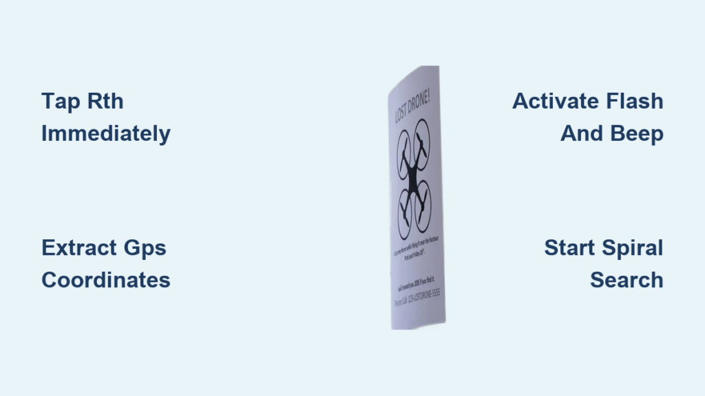
Tap RTH the Millisecond Signal Drops
Open your flight app and hunt for active signal bars. If you see any of these, act instantly:
– Battery percentage still updating
– GPS coordinates refreshing
– Distance reading changing
– Altitude indicator functioning
Immediately tap Return-to-Home (RTH). This single action recovers 40% of lost drones by overriding crash trajectories. If the drone responds, watch altitude climb—it’s fighting its way home. Never assume the link is dead; weak signals often reconnect during RTH activation.
Document Critical Data in Under 60 Seconds
While the drone may still be airborne, screenshot everything:
– Exact battery percentage at signal loss
– Final altitude and horizontal distance
– Direction the drone was traveling
– Time stamp of disconnection
Leave your controller powered on for 30 minutes minimum. Drones with critically low batteries sometimes reboot mid-fall, re-establishing connection as they hit ground. Warning: Closing the app kills this lifeline—keep it running even if the screen shows “No Signal.”
Pinpoint Last GPS Coordinates Immediately
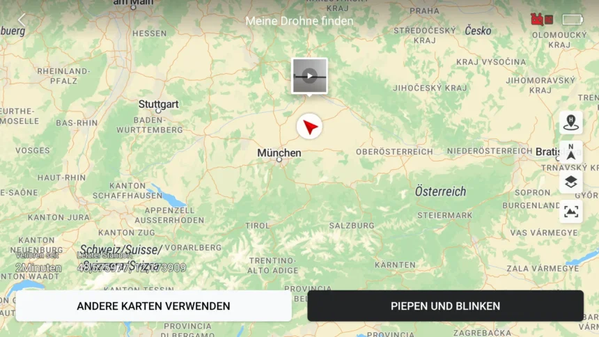
Your drone’s final digital footprint is your search starting point. Ignoring this step wastes hours scanning irrelevant terrain. GPS data accuracy varies wildly based on satellite lock strength, but it’s your most reliable anchor.
Extract Coordinates via DJI Fly App (30-Second Method)
- Tap the aircraft icon on your map screen
- Select “Find My Drone” in the menu
- Press the coordinates to launch Google Maps
- Drop a pin and save the location to your phone
This works for DJI Mavic, Phantom, and Air series drones. If coordinates appear grayed out, your drone lost GPS lock before crashing—proceed to flight log analysis immediately.
Decode Flight Logs for Hidden Clues (5-Minute Protocol)
Access deeper telemetry through flight logs:
– DJI Fly: Profile → More → Flight Data Center → select flight
– Third-party tools: Upload .txt logs to PhantomHelp Log Viewer
– Cross-reference: Match logs with screen recordings for landmark identification
Critical insight: GPS accuracy plummets to ±50 meters with weak satellite lock. Always expand your search radius by 100 meters—your drone could be hidden in the next field over.
Activate Emergency Audio and Visual Signals
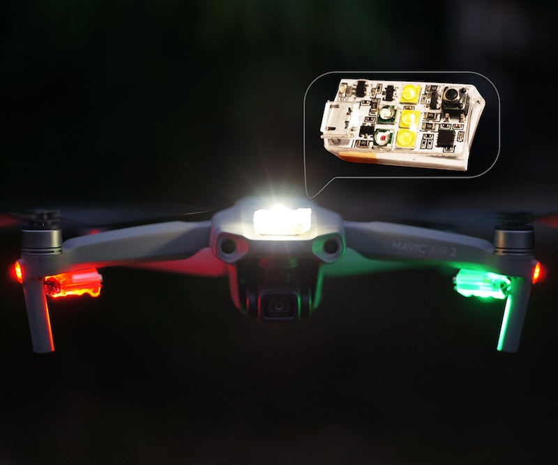
If your drone retains even 5% battery, built-in locators become your homing beacon. These features work silently until you trigger them through the app—wasting time searching blindly ignores this powerful tool.
Trigger “Flash and Beep” Before Power Dies
In the Find My Drone menu:
– Tap “Start Flashing and Beeping”
– Listen for rapid beeps (audible up to 50m in quiet areas)
– Scan for red LED strobes in shadows or vegetation
Pro tip: These signals drain residual battery fast—activate them only when you’re within 100 meters of the last GPS point. Move toward the sound while shielding your eyes from sun glare to spot flashing lights.
Night Recovery Tactics That Actually Work
When darkness falls:
– Cycle LEDs on/off repeatedly via the app to create a pulsing signal
– Use 1000+ lumen flashlights with strobe mode to illuminate treetops
– Deploy thermal cameras to detect heat signatures from warm batteries
– Organize group searches with two-person teams covering opposite quadrants
Expert note: Heat signatures fade after 6 hours. Prioritize thermal scans during the first critical search window.
Execute Professional Search Patterns

Amateur searches fail by scanning randomly. Professional drone recovery teams use military-grade search patterns that maximize coverage while minimizing missed spots. Start immediately after securing GPS coordinates.
Spiral Search Pattern for Maximum Coverage
Begin at the GPS marker and walk an expanding spiral:
– 10-meter radius for initial sweep
– Double radius with each full rotation
– Mark searched zones with sticks or survey tape
– Scan vertically with binoculars before advancing
This method covers 90% more terrain than grid searches while preventing backtracking. Time estimate: 20 minutes to cover a 100m radius field.
Calculate Realistic Glide Distance
Your drone doesn’t drop like a rock after signal loss. Estimate travel distance using:
Glide range = Remaining battery % × Average speed × 0.7
Example: 25% battery × 12 m/s × 0.7 = 210m potential glide path. Focus searches downwind from last coordinates—wind carries drones farther than pilots expect.
Terrain-Specific Search Hacks
- Forests: Concentrate on canopy gaps and clearings—drones rarely lodge in dense foliage
- Water bodies: Mark the GPS point, then search shorelines 24-48 hours later as currents carry debris
- Urban areas: Check rooftop HVAC units and parking structure ledges (drones often auto-land on flat surfaces)
- Hilly terrain: Search downhill slopes—the drone follows gravity after power loss
Handle GPS Failure Scenarios Like a Pro
When coordinates are unreliable or missing, traditional methods fail. These advanced tactics recover drones even when GPS data is corrupted or absent.
ATTI Mode Crash Recovery Protocol
If your drone entered ATTI mode (no GPS stabilization):
1. Extract the last valid coordinate before GPS failure
2. Draw a vector line along your intended flight path
3. Search a 100-meter corridor along this bearing
4. Add 20° to downwind side for wind drift compensation
Key insight: Video feed analysis is crucial here—review screen recordings for last visible landmarks like distinctive trees or buildings.
Water Landing Emergency Response
For drones downed in water:
– Mark surface coordinates immediately with buoy or phone GPS
– Wait 24-48 hours for currents to wash debris ashore
– Use polarized sunglasses to spot submerged drones through surface glare
– Rinse recovered units with distilled water within 2 hours to prevent corrosion
Critical step: Never dive after submerged drones—wait for natural recovery or deploy an underwater ROV.
Leverage Community Drone Recovery Networks
Your local drone community can triple search coverage. Most recovered drones are found through coordinated efforts—not solo searches.
Craft Effective Lost Drone Posts
Include these must-have details in Facebook groups or Reddit:
– Exact time, date, and coordinates of last signal
– Clear photo of your specific drone model (showing unique stickers)
– Flight path direction and estimated glide distance
– Modest reward offer ($25-$100) to incentivize searches
Best platforms: Local RC flying club forums, DroneLogbook’s recovery section, and regional Facebook drone groups with 500+ members.
Deploy Advanced Search Technology
- Second drone reconnaissance: Fly a backup drone at 50m altitude with 4K camera
- Thermal imaging: Detects battery heat signatures up to 6 hours post-crash
- Fixed-wing search aircraft: Covers 10x more ground than multirotors
- Professional SAR services: Licensed pilots with drone recovery expertise
Prevent Future Drone Losses Immediately
Every recovered drone teaches hard lessons. Implement these fixes before your next flight to avoid repeating this nightmare.
Essential Pre-Flight Safety Checklist
- Verify 4+ GPS satellite bars before takeoff (never fly with 3 bars)
- Confirm Home Point “H” marker appears on screen
- Set RTH altitude 20m above tallest obstacle (not default 100m)
- Check battery cell balance in app settings
- Complete firmware updates 24 hours before flying
Must-Have Hardware Add-Ons
- AirTag or Tile tracker: Taped inside battery compartment
- Dedicated GPS tracker: Marco Polo for real-time location
- Waterproof contact label: With phone number on landing gear
- Hull-loss insurance: DJI Care Refresh covers accidental loss
Flight Discipline Rules That Save Drones
- Never exceed 50% battery from home point
- Abandon flight if wind exceeds 15 mph
- Maintain visual line of sight at all times
- Land immediately at 30% battery (not waiting for RTH warning)
Emergency Recovery Checklist
| Step | Critical Action | Time Limit |
|——|—————-|————|
| 1 | Tap RTH instantly | First 30 seconds |
| 2 | Screenshot final telemetry | First 2 minutes |
| 3 | Activate “Flash and Beep” | First 5 minutes |
| 4 | Download flight logs | First 15 minutes |
| 5 | Begin spiral search | Within 30 minutes |
| 6 | Post to drone networks | Within 2 hours |
Your safety outweighs equipment recovery—never climb unstable structures or enter hazardous terrain. Most drones are recovered within 120 minutes when these steps are followed systematically. Implement the prevention checklist before your next flight, and you’ll never face this heart-stopping moment again. The sky belongs to disciplined pilots—fly smart, recover faster.